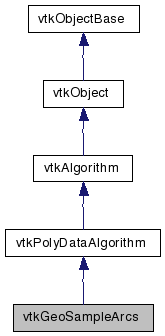
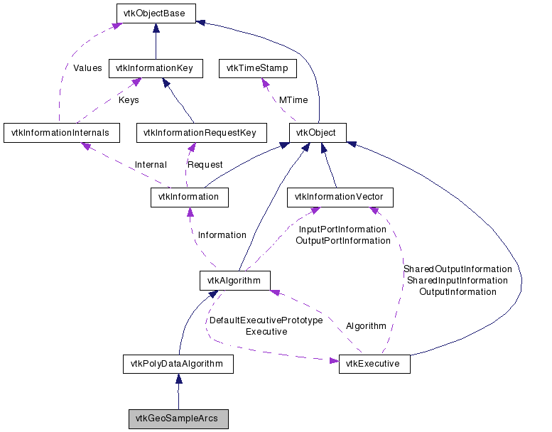
vtkGeoSampleArcs Class Reference
#include <vtkGeoSampleArcs.h>


Detailed Description
Samples geospatial lines at regular intervals.vtkGeoSampleArcs refines lines in the input polygonal data so that the distance between adjacent points is no more than a threshold distance. Points are interpolated along the surface of the globe. This is useful in order to keep lines such as political boundaries from intersecting the globe and becoming invisible.
Definition at line 36 of file vtkGeoSampleArcs.h.
Public Types | |
| typedef vtkPolyDataAlgorithm | Superclass |
Public Member Functions | |
| virtual const char * | GetClassName () |
| virtual int | IsA (const char *type) |
| void | PrintSelf (ostream &os, vtkIndent indent) |
| virtual void | SetGlobeRadius (double) |
| virtual double | GetGlobeRadius () |
| virtual void | SetMaximumDistanceMeters (double) |
| virtual double | GetMaximumDistanceMeters () |
Static Public Member Functions | |
| static vtkGeoSampleArcs * | New () |
| static int | IsTypeOf (const char *type) |
| static vtkGeoSampleArcs * | SafeDownCast (vtkObject *o) |
Protected Member Functions | |
| vtkGeoSampleArcs () | |
| ~vtkGeoSampleArcs () | |
| int | RequestData (vtkInformation *, vtkInformationVector **, vtkInformationVector *) |
Protected Attributes | |
| double | GlobeRadius |
| double | MaximumDistanceMeters |
Member Typedef Documentation
Constructor & Destructor Documentation
| vtkGeoSampleArcs::vtkGeoSampleArcs | ( | ) | [protected] |
| vtkGeoSampleArcs::~vtkGeoSampleArcs | ( | ) | [protected] |
Member Function Documentation
| static vtkGeoSampleArcs* vtkGeoSampleArcs::New | ( | ) | [static] |
Create an object with Debug turned off, modified time initialized to zero, and reference counting on.
Reimplemented from vtkPolyDataAlgorithm.
| virtual const char* vtkGeoSampleArcs::GetClassName | ( | ) | [virtual] |
Reimplemented from vtkPolyDataAlgorithm.
| static int vtkGeoSampleArcs::IsTypeOf | ( | const char * | name | ) | [static] |
Return 1 if this class type is the same type of (or a subclass of) the named class. Returns 0 otherwise. This method works in combination with vtkTypeRevisionMacro found in vtkSetGet.h.
Reimplemented from vtkPolyDataAlgorithm.
| virtual int vtkGeoSampleArcs::IsA | ( | const char * | name | ) | [virtual] |
Return 1 if this class is the same type of (or a subclass of) the named class. Returns 0 otherwise. This method works in combination with vtkTypeRevisionMacro found in vtkSetGet.h.
Reimplemented from vtkPolyDataAlgorithm.
| static vtkGeoSampleArcs* vtkGeoSampleArcs::SafeDownCast | ( | vtkObject * | o | ) | [static] |
Reimplemented from vtkPolyDataAlgorithm.
| void vtkGeoSampleArcs::PrintSelf | ( | ostream & | os, | |
| vtkIndent | indent | |||
| ) | [virtual] |
Methods invoked by print to print information about the object including superclasses. Typically not called by the user (use Print() instead) but used in the hierarchical print process to combine the output of several classes.
Reimplemented from vtkPolyDataAlgorithm.
| virtual void vtkGeoSampleArcs::SetGlobeRadius | ( | double | ) | [virtual] |
The base radius used to determine the earth's surface. Default is the earth's radius in meters. TODO: Change this to take in a vtkGeoTerrain to get altitude.
| virtual double vtkGeoSampleArcs::GetGlobeRadius | ( | ) | [virtual] |
The base radius used to determine the earth's surface. Default is the earth's radius in meters. TODO: Change this to take in a vtkGeoTerrain to get altitude.
| virtual void vtkGeoSampleArcs::SetMaximumDistanceMeters | ( | double | ) | [virtual] |
The maximum distance, in meters, between adjacent points.
| virtual double vtkGeoSampleArcs::GetMaximumDistanceMeters | ( | ) | [virtual] |
The maximum distance, in meters, between adjacent points.
| int vtkGeoSampleArcs::RequestData | ( | vtkInformation * | , | |
| vtkInformationVector ** | , | |||
| vtkInformationVector * | ||||
| ) | [protected, virtual] |
Convert the vtkGraph into vtkPolyData.
Reimplemented from vtkPolyDataAlgorithm.
Member Data Documentation
double vtkGeoSampleArcs::GlobeRadius [protected] |
Definition at line 65 of file vtkGeoSampleArcs.h.
double vtkGeoSampleArcs::MaximumDistanceMeters [protected] |
Definition at line 66 of file vtkGeoSampleArcs.h.
The documentation for this class was generated from the following file:
- dox/Geovis/vtkGeoSampleArcs.h
 1.5.6
1.5.6