vtkEarthSource Class Reference
#include <vtkEarthSource.h>


Detailed Description
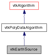
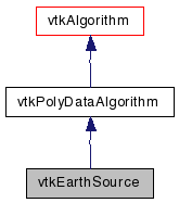
create the continents of the Earth as a spherevtkEarthSource creates a spherical rendering of the geographical shapes of the major continents of the earth. The OnRatio determines how much of the data is actually used. The radius defines the radius of the sphere at which the continents are placed. Obtains data from an imbedded array of coordinates.
- Tests:
- vtkEarthSource (Tests)
Definition at line 33 of file vtkEarthSource.h.
Public Types | |
| typedef vtkPolyDataAlgorithm | Superclass |
Public Member Functions | |
| virtual const char * | GetClassName () |
| virtual int | IsA (const char *type) |
| void | PrintSelf (ostream &os, vtkIndent indent) |
| virtual void | SetRadius (double) |
| virtual double | GetRadius () |
| virtual void | SetOnRatio (int) |
| virtual int | GetOnRatio () |
| virtual void | SetOutline (int) |
| virtual int | GetOutline () |
| virtual void | OutlineOn () |
| virtual void | OutlineOff () |
Static Public Member Functions | |
| static vtkEarthSource * | New () |
| static int | IsTypeOf (const char *type) |
| static vtkEarthSource * | SafeDownCast (vtkObject *o) |
Protected Member Functions | |
| vtkEarthSource () | |
| ~vtkEarthSource () | |
| int | RequestData (vtkInformation *, vtkInformationVector **, vtkInformationVector *) |
Protected Attributes | |
| double | Radius |
| int | OnRatio |
| int | Outline |
Member Typedef Documentation
Constructor & Destructor Documentation
| vtkEarthSource::vtkEarthSource | ( | ) | [protected] |
| vtkEarthSource::~vtkEarthSource | ( | ) | [inline, protected] |
Definition at line 66 of file vtkEarthSource.h.
Member Function Documentation
| static vtkEarthSource* vtkEarthSource::New | ( | ) | [static] |
Create an object with Debug turned off, modified time initialized to zero, and reference counting on.
Reimplemented from vtkPolyDataAlgorithm.
| virtual const char* vtkEarthSource::GetClassName | ( | ) | [virtual] |
Reimplemented from vtkPolyDataAlgorithm.
| static int vtkEarthSource::IsTypeOf | ( | const char * | name | ) | [static] |
Return 1 if this class type is the same type of (or a subclass of) the named class. Returns 0 otherwise. This method works in combination with vtkTypeMacro found in vtkSetGet.h.
Reimplemented from vtkPolyDataAlgorithm.
| virtual int vtkEarthSource::IsA | ( | const char * | name | ) | [virtual] |
Return 1 if this class is the same type of (or a subclass of) the named class. Returns 0 otherwise. This method works in combination with vtkTypeMacro found in vtkSetGet.h.
Reimplemented from vtkPolyDataAlgorithm.
| static vtkEarthSource* vtkEarthSource::SafeDownCast | ( | vtkObject * | o | ) | [static] |
Reimplemented from vtkPolyDataAlgorithm.
| void vtkEarthSource::PrintSelf | ( | ostream & | os, | |
| vtkIndent | indent | |||
| ) | [virtual] |
Methods invoked by print to print information about the object including superclasses. Typically not called by the user (use Print() instead) but used in the hierarchical print process to combine the output of several classes.
Reimplemented from vtkPolyDataAlgorithm.
| virtual void vtkEarthSource::SetRadius | ( | double | ) | [virtual] |
Set radius of earth.
| virtual double vtkEarthSource::GetRadius | ( | ) | [virtual] |
Set radius of earth.
| virtual void vtkEarthSource::SetOnRatio | ( | int | ) | [virtual] |
Turn on every nth entity. This controls how much detail the model will have. The maximum ratio is sixteen. (The smaller OnRatio, the more detail there is.)
| virtual int vtkEarthSource::GetOnRatio | ( | ) | [virtual] |
Turn on every nth entity. This controls how much detail the model will have. The maximum ratio is sixteen. (The smaller OnRatio, the more detail there is.)
| virtual void vtkEarthSource::SetOutline | ( | int | ) | [virtual] |
Turn on/off drawing continents as filled polygons or as wireframe outlines. Warning: some graphics systems will have trouble with the very large, concave filled polygons. Recommend you use OutlienOn (i.e., disable filled polygons) for now.
| virtual int vtkEarthSource::GetOutline | ( | ) | [virtual] |
Turn on/off drawing continents as filled polygons or as wireframe outlines. Warning: some graphics systems will have trouble with the very large, concave filled polygons. Recommend you use OutlienOn (i.e., disable filled polygons) for now.
| virtual void vtkEarthSource::OutlineOn | ( | ) | [virtual] |
Turn on/off drawing continents as filled polygons or as wireframe outlines. Warning: some graphics systems will have trouble with the very large, concave filled polygons. Recommend you use OutlienOn (i.e., disable filled polygons) for now.
| virtual void vtkEarthSource::OutlineOff | ( | ) | [virtual] |
Turn on/off drawing continents as filled polygons or as wireframe outlines. Warning: some graphics systems will have trouble with the very large, concave filled polygons. Recommend you use OutlienOn (i.e., disable filled polygons) for now.
| int vtkEarthSource::RequestData | ( | vtkInformation * | request, | |
| vtkInformationVector ** | inputVector, | |||
| vtkInformationVector * | outputVector | |||
| ) | [protected, virtual] |
This is called by the superclass. This is the method you should override.
Reimplemented from vtkPolyDataAlgorithm.
Member Data Documentation
double vtkEarthSource::Radius [protected] |
Definition at line 70 of file vtkEarthSource.h.
int vtkEarthSource::OnRatio [protected] |
Definition at line 71 of file vtkEarthSource.h.
int vtkEarthSource::Outline [protected] |
Definition at line 72 of file vtkEarthSource.h.
The documentation for this class was generated from the following file:
- dox/Hybrid/vtkEarthSource.h
 1.5.6
1.5.6