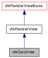
vtkGeoView Class Reference
#include <vtkGeoView.h>


Detailed Description
A 3D geospatial view.vtkGeoView is a 3D globe view. The globe may contain a multi-resolution geometry source (vtkGeoTerrain), multiple multi-resolution image sources (vtkGeoAlignedImageRepresentation), as well as other representations such as vtkRenderedGraphRepresentation. At a minimum, the view must have a terrain and one image representation. The view uses vtkGeoInteractorStyle to orbit, zoom, and tilt the view, and contains a vtkCompassWidget for manipulating the camera.
Each terrain or image representation contains a vtkGeoSource subclass which generates geometry or imagery at multiple resolutions. As the camera position changes, the terrain and/or image representations may ask its vtkGeoSource to refine the geometry. This refinement is performed on a separate thread, and the data is added to the view when it becomes available.
- Examples:
- vtkGeoView (Examples)
- Tests:
- vtkGeoView (Tests)
Definition at line 63 of file vtkGeoView.h.
Member Typedef Documentation
| typedef vtkRenderView vtkGeoView::Superclass |
Constructor & Destructor Documentation
| vtkGeoView::vtkGeoView | ( | ) | [protected] |
| vtkGeoView::~vtkGeoView | ( | ) | [protected] |
Member Function Documentation
| static vtkGeoView* vtkGeoView::New | ( | ) | [static] |
Create an object with Debug turned off, modified time initialized to zero, and reference counting on.
Reimplemented from vtkRenderView.
| virtual const char* vtkGeoView::GetClassName | ( | ) | [virtual] |
Reimplemented from vtkRenderView.
| static int vtkGeoView::IsTypeOf | ( | const char * | name | ) | [static] |
Return 1 if this class type is the same type of (or a subclass of) the named class. Returns 0 otherwise. This method works in combination with vtkTypeMacro found in vtkSetGet.h.
Reimplemented from vtkRenderView.
| virtual int vtkGeoView::IsA | ( | const char * | name | ) | [virtual] |
Return 1 if this class is the same type of (or a subclass of) the named class. Returns 0 otherwise. This method works in combination with vtkTypeMacro found in vtkSetGet.h.
Reimplemented from vtkRenderView.
| static vtkGeoView* vtkGeoView::SafeDownCast | ( | vtkObject * | o | ) | [static] |
Reimplemented from vtkRenderView.
| void vtkGeoView::PrintSelf | ( | ostream & | os, | |
| vtkIndent | indent | |||
| ) | [virtual] |
Methods invoked by print to print information about the object including superclasses. Typically not called by the user (use Print() instead) but used in the hierarchical print process to combine the output of several classes.
Reimplemented from vtkRenderView.
| vtkGeoAlignedImageRepresentation* vtkGeoView::AddDefaultImageRepresentation | ( | vtkImageData * | image | ) |
Adds an image representation with a simple terrain model using the image in the specified file as the globe terrain.
| virtual void vtkGeoView::PrepareForRendering | ( | ) | [virtual] |
Prepares the view for rendering.
Reimplemented from vtkRenderView.
| void vtkGeoView::BuildLowResEarth | ( | double | origin[3] | ) |
Rebuild low-res earth source; call after (re)setting origin.
| virtual void vtkGeoView::SetLockHeading | ( | bool | lock | ) | [virtual] |
Whether the view locks the heading when panning. Default is off.
| virtual bool vtkGeoView::GetLockHeading | ( | ) | [virtual] |
Whether the view locks the heading when panning. Default is off.
| virtual void vtkGeoView::LockHeadingOn | ( | ) | [virtual] |
Whether the view locks the heading when panning. Default is off.
| virtual void vtkGeoView::LockHeadingOff | ( | ) | [virtual] |
Whether the view locks the heading when panning. Default is off.
| vtkGeoInteractorStyle* vtkGeoView::GetGeoInteractorStyle | ( | ) |
Convenience method for obtaining the internal interactor style.
| virtual void vtkGeoView::SetGeoInteractorStyle | ( | vtkGeoInteractorStyle * | style | ) | [virtual] |
Method to change the interactor style.
| virtual void vtkGeoView::SetTerrain | ( | vtkGeoTerrain * | terrain | ) | [virtual] |
The terrain (geometry) model for this earth view.
| virtual vtkGeoTerrain* vtkGeoView::GetTerrain | ( | ) | [virtual] |
The terrain (geometry) model for this earth view.
| virtual void vtkGeoView::Render | ( | ) | [virtual] |
Update and render the view.
Reimplemented from vtkRenderView.
Member Data Documentation
vtkGlobeSource* vtkGeoView::LowResEarthSource [protected] |
Definition at line 106 of file vtkGeoView.h.
vtkPolyDataMapper* vtkGeoView::LowResEarthMapper [protected] |
Definition at line 107 of file vtkGeoView.h.
vtkActor* vtkGeoView::LowResEarthActor [protected] |
Definition at line 108 of file vtkGeoView.h.
vtkAssembly* vtkGeoView::Assembly [protected] |
Definition at line 109 of file vtkGeoView.h.
vtkGeoTerrain* vtkGeoView::Terrain [protected] |
Definition at line 110 of file vtkGeoView.h.
int vtkGeoView::UsingMesaDrivers [protected] |
Definition at line 112 of file vtkGeoView.h.
The documentation for this class was generated from the following file:
- dox/Geovis/vtkGeoView.h
 1.5.6
1.5.6