A 3D terrain model for the globe. More...
#include <vtkGeoTerrain.h>
Detailed Description
A 3D terrain model for the globe.
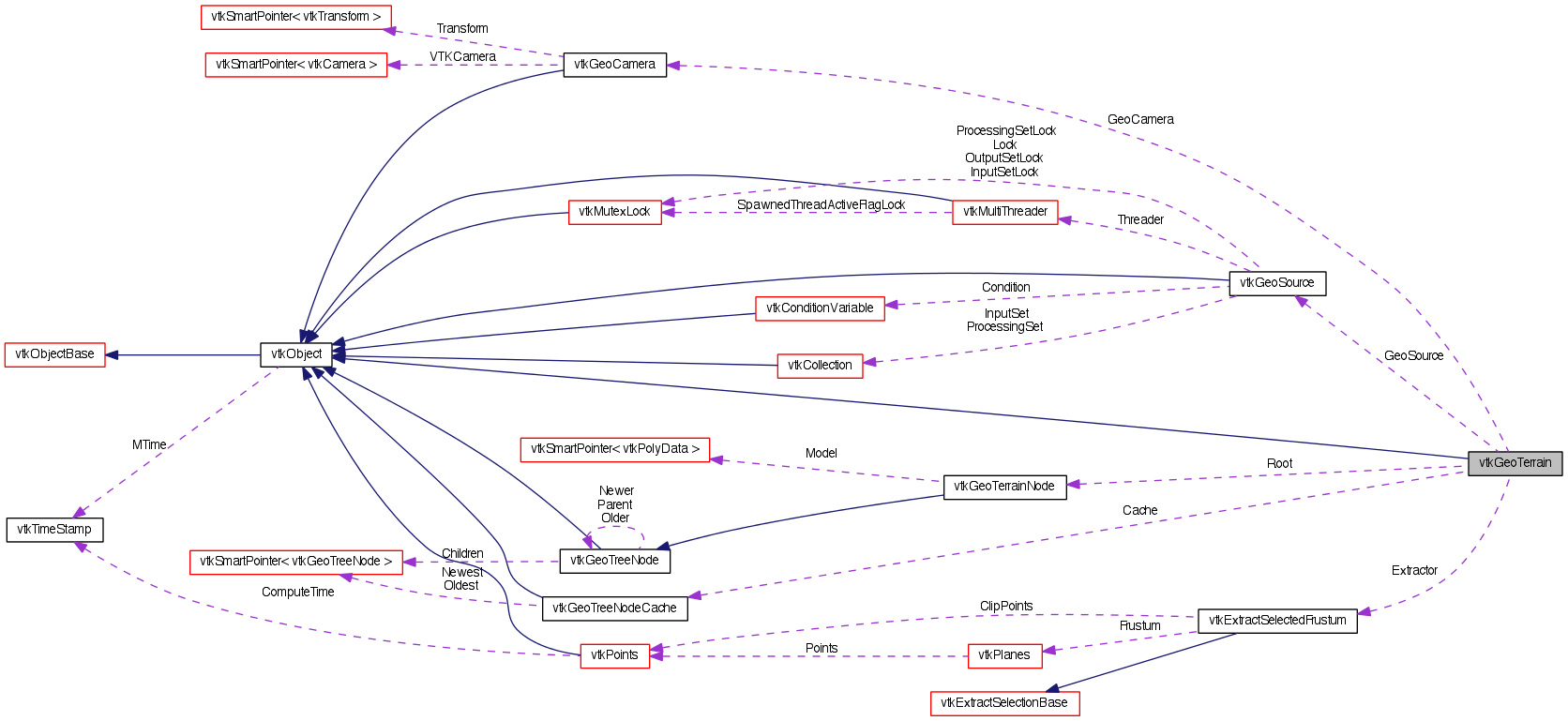
vtkGeoTerrain contains a multi-resolution tree of geometry representing the globe. It uses a vtkGeoSource subclass to generate the terrain, such as vtkGeoGlobeSource. This source must be set before using the terrain in a vtkGeoView. The terrain also contains an AddActors() method which will update the set of actors representing the globe given the current camera position.
- Tests:
- vtkGeoTerrain (Tests)
Definition at line 50 of file vtkGeoTerrain.h.
Member Typedef Documentation
| typedef vtkObject vtkGeoTerrain::Superclass |
Reimplemented from vtkObject.
Reimplemented in vtkGeoTerrain2D.
Definition at line 54 of file vtkGeoTerrain.h.
Constructor & Destructor Documentation
| vtkGeoTerrain::vtkGeoTerrain | ( | ) | [protected] |
| vtkGeoTerrain::~vtkGeoTerrain | ( | ) | [protected] |
Member Function Documentation
| static vtkGeoTerrain* vtkGeoTerrain::New | ( | ) | [static] |
Create an object with Debug turned off, modified time initialized to zero, and reference counting on.
Reimplemented from vtkObject.
Reimplemented in vtkGeoTerrain2D.
| static int vtkGeoTerrain::IsTypeOf | ( | const char * | name | ) | [static] |
Return 1 if this class type is the same type of (or a subclass of) the named class. Returns 0 otherwise. This method works in combination with vtkTypeMacro found in vtkSetGet.h.
Reimplemented from vtkObject.
Reimplemented in vtkGeoTerrain2D.
| virtual int vtkGeoTerrain::IsA | ( | const char * | name | ) | [virtual] |
Return 1 if this class is the same type of (or a subclass of) the named class. Returns 0 otherwise. This method works in combination with vtkTypeMacro found in vtkSetGet.h.
Reimplemented from vtkObject.
Reimplemented in vtkGeoTerrain2D.
| static vtkGeoTerrain* vtkGeoTerrain::SafeDownCast | ( | vtkObjectBase * | o | ) | [static] |
Reimplemented from vtkObject.
Reimplemented in vtkGeoTerrain2D.
| virtual vtkObjectBase* vtkGeoTerrain::NewInstanceInternal | ( | ) | const [protected, virtual] |
Reimplemented from vtkObject.
Reimplemented in vtkGeoTerrain2D.
| vtkGeoTerrain* vtkGeoTerrain::NewInstance | ( | ) | const |
Reimplemented from vtkObject.
Reimplemented in vtkGeoTerrain2D.
| virtual void vtkGeoTerrain::PrintSelf | ( | ostream & | os, |
| vtkIndent | indent | ||
| ) | [virtual] |
Methods invoked by print to print information about the object including superclasses. Typically not called by the user (use Print() instead) but used in the hierarchical print process to combine the output of several classes.
Reimplemented from vtkObject.
Reimplemented in vtkGeoTerrain2D.
| virtual vtkGeoSource* vtkGeoTerrain::GetSource | ( | ) | [inline, virtual] |
The source used to obtain geometry patches.
Definition at line 59 of file vtkGeoTerrain.h.
| virtual void vtkGeoTerrain::SetSource | ( | vtkGeoSource * | source | ) | [virtual] |
The source used to obtain geometry patches.
| void vtkGeoTerrain::SaveDatabase | ( | const char * | path, |
| int | depth | ||
| ) |
Save the set of patches up to a given maximum depth.
| void vtkGeoTerrain::AddActors | ( | vtkRenderer * | ren, |
| vtkAssembly * | assembly, | ||
| vtkCollection * | imageReps | ||
| ) |
Update the actors in an assembly used to render the globe. ren is the current renderer, and imageReps holds the collection of vtkGeoAlignedImageRepresentations that will be blended together to form the image on the globe.
| virtual void vtkGeoTerrain::SetOrigin | ( | double | , |
| double | , | ||
| double | |||
| ) | [virtual] |
The world-coordinate origin offset used to eliminate precision errors when zoomed in to a particular region of the globe.
| virtual void vtkGeoTerrain::SetOrigin | ( | double | [3] | ) | [virtual] |
The world-coordinate origin offset used to eliminate precision errors when zoomed in to a particular region of the globe.
| virtual double* vtkGeoTerrain::GetOrigin | ( | ) | [virtual] |
The world-coordinate origin offset used to eliminate precision errors when zoomed in to a particular region of the globe.
| virtual void vtkGeoTerrain::GetOrigin | ( | double & | , |
| double & | , | ||
| double & | |||
| ) | [virtual] |
The world-coordinate origin offset used to eliminate precision errors when zoomed in to a particular region of the globe.
| virtual void vtkGeoTerrain::GetOrigin | ( | double | [3] | ) | [virtual] |
The world-coordinate origin offset used to eliminate precision errors when zoomed in to a particular region of the globe.
| virtual void vtkGeoTerrain::SetMaxLevel | ( | int | ) | [virtual] |
The maximum level of the terrain tree.
| virtual int vtkGeoTerrain::GetMaxLevel | ( | ) | [virtual] |
The maximum level of the terrain tree.
| virtual void vtkGeoTerrain::SetGeoSource | ( | vtkGeoSource * | source | ) | [protected, virtual] |
| void vtkGeoTerrain::Initialize | ( | ) | [protected] |
Initialize the terrain with a new source.
| virtual void vtkGeoTerrain::InitializeNodeAnalysis | ( | vtkRenderer * | ren | ) | [protected, virtual] |
AddActors() calls this to setup parameters for evaluating nodes.
Reimplemented in vtkGeoTerrain2D.
| virtual bool vtkGeoTerrain::NodeInViewport | ( | vtkGeoTerrainNode * | node | ) | [protected, virtual] |
AddActors() calls this to determine if a node is in the current viewport.
Reimplemented in vtkGeoTerrain2D.
| virtual int vtkGeoTerrain::EvaluateNode | ( | vtkGeoTerrainNode * | node | ) | [protected, virtual] |
AddActors() calls to to evaluate whether a node should be refined (1), coarsened (-1), or remain at the same level (0).
Reimplemented in vtkGeoTerrain2D.
| void vtkGeoTerrain::PrintTree | ( | ostream & | os, |
| vtkIndent | indent, | ||
| vtkGeoTerrainNode * | node | ||
| ) | [protected] |
Print the tree of terrain nodes.
| virtual void vtkGeoTerrain::SetGeoCamera | ( | vtkGeoCamera * | camera | ) | [protected, virtual] |
Member Data Documentation
vtkGeoSource* vtkGeoTerrain::GeoSource [protected] |
Definition at line 96 of file vtkGeoTerrain.h.
vtkGeoTerrainNode* vtkGeoTerrain::Root [protected] |
Definition at line 97 of file vtkGeoTerrain.h.
vtkGeoTreeNodeCache* vtkGeoTerrain::Cache [protected] |
Definition at line 98 of file vtkGeoTerrain.h.
double vtkGeoTerrain::Origin[3] [protected] |
Definition at line 117 of file vtkGeoTerrain.h.
vtkExtractSelectedFrustum* vtkGeoTerrain::Extractor [protected] |
Definition at line 118 of file vtkGeoTerrain.h.
vtkGeoCamera* vtkGeoTerrain::GeoCamera [protected] |
Definition at line 120 of file vtkGeoTerrain.h.
int vtkGeoTerrain::MaxLevel [protected] |
Definition at line 121 of file vtkGeoTerrain.h.
The documentation for this class was generated from the following file:
- dox/Geovis/Core/vtkGeoTerrain.h