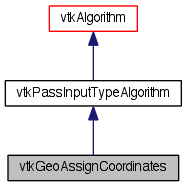
Given latitude and longitude arrays, take the values in those arrays and convert them to x,y,z world coordinates. More...
#include <vtkGeoAssignCoordinates.h>


Detailed Description
Given latitude and longitude arrays, take the values in those arrays and convert them to x,y,z world coordinates.
Givem latitude and longitude arrays, take the values in those arrays and convert them to x,y,z world coordinates. Uses a spherical model of the earth to do the conversion. The position is in meters relative to the center of the earth.
If a transform is given, use the transform to convert latitude and longitude to the world coordinate.
Definition at line 45 of file vtkGeoAssignCoordinates.h.
Member Typedef Documentation
Reimplemented from vtkPassInputTypeAlgorithm.
Definition at line 50 of file vtkGeoAssignCoordinates.h.
Constructor & Destructor Documentation
| vtkGeoAssignCoordinates::vtkGeoAssignCoordinates | ( | ) | [protected] |
| vtkGeoAssignCoordinates::~vtkGeoAssignCoordinates | ( | ) | [protected] |
Member Function Documentation
| static vtkGeoAssignCoordinates* vtkGeoAssignCoordinates::New | ( | ) | [static] |
Create an object with Debug turned off, modified time initialized to zero, and reference counting on.
Reimplemented from vtkPassInputTypeAlgorithm.
| static int vtkGeoAssignCoordinates::IsTypeOf | ( | const char * | name | ) | [static] |
Return 1 if this class type is the same type of (or a subclass of) the named class. Returns 0 otherwise. This method works in combination with vtkTypeMacro found in vtkSetGet.h.
Reimplemented from vtkPassInputTypeAlgorithm.
| virtual int vtkGeoAssignCoordinates::IsA | ( | const char * | name | ) | [virtual] |
Return 1 if this class is the same type of (or a subclass of) the named class. Returns 0 otherwise. This method works in combination with vtkTypeMacro found in vtkSetGet.h.
Reimplemented from vtkPassInputTypeAlgorithm.
| static vtkGeoAssignCoordinates* vtkGeoAssignCoordinates::SafeDownCast | ( | vtkObjectBase * | o | ) | [static] |
Reimplemented from vtkPassInputTypeAlgorithm.
| virtual vtkObjectBase* vtkGeoAssignCoordinates::NewInstanceInternal | ( | ) | const [protected, virtual] |
Reimplemented from vtkPassInputTypeAlgorithm.
Reimplemented from vtkPassInputTypeAlgorithm.
| void vtkGeoAssignCoordinates::PrintSelf | ( | ostream & | os, |
| vtkIndent | indent | ||
| ) | [virtual] |
Methods invoked by print to print information about the object including superclasses. Typically not called by the user (use Print() instead) but used in the hierarchical print process to combine the output of several classes.
Reimplemented from vtkPassInputTypeAlgorithm.
| virtual void vtkGeoAssignCoordinates::SetLongitudeArrayName | ( | const char * | ) | [virtual] |
Set the longitude coordinate array name.
| virtual char* vtkGeoAssignCoordinates::GetLongitudeArrayName | ( | ) | [virtual] |
Set the longitude coordinate array name.
| virtual void vtkGeoAssignCoordinates::SetLatitudeArrayName | ( | const char * | ) | [virtual] |
Set the latitude coordinate array name.
| virtual char* vtkGeoAssignCoordinates::GetLatitudeArrayName | ( | ) | [virtual] |
Set the latitude coordinate array name.
| virtual void vtkGeoAssignCoordinates::SetGlobeRadius | ( | double | ) | [virtual] |
The base radius to use in GLOBAL mode. Default is the earth's radius.
| virtual double vtkGeoAssignCoordinates::GetGlobeRadius | ( | ) | [virtual] |
The base radius to use in GLOBAL mode. Default is the earth's radius.
| virtual void vtkGeoAssignCoordinates::SetTransform | ( | vtkAbstractTransform * | trans | ) | [virtual] |
The transform to use to convert coordinates of the form (lat, long, 0) to (x, y z). If this is NULL (the default), use GlobeRadius to perform a spherical embedding.
| virtual vtkAbstractTransform* vtkGeoAssignCoordinates::GetTransform | ( | ) | [virtual] |
The transform to use to convert coordinates of the form (lat, long, 0) to (x, y z). If this is NULL (the default), use GlobeRadius to perform a spherical embedding.
| virtual void vtkGeoAssignCoordinates::SetCoordinatesInArrays | ( | bool | ) | [virtual] |
If on, uses LatitudeArrayName and LongitudeArrayName to move values in data arrays into the points of the data set. Turn off if the latitude and longitude are already in the points.
| virtual bool vtkGeoAssignCoordinates::GetCoordinatesInArrays | ( | ) | [virtual] |
If on, uses LatitudeArrayName and LongitudeArrayName to move values in data arrays into the points of the data set. Turn off if the latitude and longitude are already in the points.
| virtual void vtkGeoAssignCoordinates::CoordinatesInArraysOn | ( | ) | [virtual] |
If on, uses LatitudeArrayName and LongitudeArrayName to move values in data arrays into the points of the data set. Turn off if the latitude and longitude are already in the points.
| virtual void vtkGeoAssignCoordinates::CoordinatesInArraysOff | ( | ) | [virtual] |
If on, uses LatitudeArrayName and LongitudeArrayName to move values in data arrays into the points of the data set. Turn off if the latitude and longitude are already in the points.
| int vtkGeoAssignCoordinates::RequestData | ( | vtkInformation * | , |
| vtkInformationVector ** | , | ||
| vtkInformationVector * | |||
| ) | [protected, virtual] |
This is called within ProcessRequest when a request asks the algorithm to do its work. This is the method you should override to do whatever the algorithm is designed to do. This happens during the fourth pass in the pipeline execution process.
Reimplemented from vtkPassInputTypeAlgorithm.
| int vtkGeoAssignCoordinates::FillInputPortInformation | ( | int | port, |
| vtkInformation * | info | ||
| ) | [protected, virtual] |
Fill the input port information objects for this algorithm. This is invoked by the first call to GetInputPortInformation for each port so subclasses can specify what they can handle.
Reimplemented from vtkPassInputTypeAlgorithm.
The documentation for this class was generated from the following file:
- /Users/kitware/Dashboards/MyTests/VTK_BLD_Release_docs/Utilities/Doxygen/dox/Geovis/Core/vtkGeoAssignCoordinates.h
 1.8.0
1.8.0