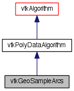
Samples geospatial lines at regular intervals. More...
#include <vtkGeoSampleArcs.h>


Detailed Description
Samples geospatial lines at regular intervals.
vtkGeoSampleArcs refines lines in the input polygonal data so that the distance between adjacent points is no more than a threshold distance. Points are interpolated along the surface of the globe. This is useful in order to keep lines such as political boundaries from intersecting the globe and becoming invisible.
Definition at line 37 of file vtkGeoSampleArcs.h.
Member Typedef Documentation
Reimplemented from vtkPolyDataAlgorithm.
Definition at line 42 of file vtkGeoSampleArcs.h.
Member Enumeration Documentation
| anonymous enum |
Definition at line 60 of file vtkGeoSampleArcs.h.
Constructor & Destructor Documentation
| vtkGeoSampleArcs::vtkGeoSampleArcs | ( | ) | [protected] |
| vtkGeoSampleArcs::~vtkGeoSampleArcs | ( | ) | [protected] |
Member Function Documentation
| static vtkGeoSampleArcs* vtkGeoSampleArcs::New | ( | ) | [static] |
Create an object with Debug turned off, modified time initialized to zero, and reference counting on.
Reimplemented from vtkPolyDataAlgorithm.
| static int vtkGeoSampleArcs::IsTypeOf | ( | const char * | name | ) | [static] |
Return 1 if this class type is the same type of (or a subclass of) the named class. Returns 0 otherwise. This method works in combination with vtkTypeMacro found in vtkSetGet.h.
Reimplemented from vtkPolyDataAlgorithm.
| virtual int vtkGeoSampleArcs::IsA | ( | const char * | name | ) | [virtual] |
Return 1 if this class is the same type of (or a subclass of) the named class. Returns 0 otherwise. This method works in combination with vtkTypeMacro found in vtkSetGet.h.
Reimplemented from vtkPolyDataAlgorithm.
| static vtkGeoSampleArcs* vtkGeoSampleArcs::SafeDownCast | ( | vtkObjectBase * | o | ) | [static] |
Reimplemented from vtkPolyDataAlgorithm.
| virtual vtkObjectBase* vtkGeoSampleArcs::NewInstanceInternal | ( | ) | const [protected, virtual] |
Reimplemented from vtkPolyDataAlgorithm.
| vtkGeoSampleArcs* vtkGeoSampleArcs::NewInstance | ( | ) | const |
Reimplemented from vtkPolyDataAlgorithm.
| void vtkGeoSampleArcs::PrintSelf | ( | ostream & | os, |
| vtkIndent | indent | ||
| ) | [virtual] |
Methods invoked by print to print information about the object including superclasses. Typically not called by the user (use Print() instead) but used in the hierarchical print process to combine the output of several classes.
Reimplemented from vtkPolyDataAlgorithm.
| virtual void vtkGeoSampleArcs::SetGlobeRadius | ( | double | ) | [virtual] |
The base radius used to determine the earth's surface. Default is the earth's radius in meters. TODO: Change this to take in a vtkGeoTerrain to get altitude.
| virtual double vtkGeoSampleArcs::GetGlobeRadius | ( | ) | [virtual] |
The base radius used to determine the earth's surface. Default is the earth's radius in meters. TODO: Change this to take in a vtkGeoTerrain to get altitude.
| virtual void vtkGeoSampleArcs::SetMaximumDistanceMeters | ( | double | ) | [virtual] |
The maximum distance, in meters, between adjacent points.
| virtual double vtkGeoSampleArcs::GetMaximumDistanceMeters | ( | ) | [virtual] |
The maximum distance, in meters, between adjacent points.
| virtual void vtkGeoSampleArcs::SetInputCoordinateSystem | ( | int | ) | [virtual] |
The input coordinate system. RECTANGULAR is x,y,z meters relative the the earth center. SPHERICAL is longitude,latitude,altitude.
| virtual int vtkGeoSampleArcs::GetInputCoordinateSystem | ( | ) | [virtual] |
The input coordinate system. RECTANGULAR is x,y,z meters relative the the earth center. SPHERICAL is longitude,latitude,altitude.
| virtual void vtkGeoSampleArcs::SetInputCoordinateSystemToRectangular | ( | ) | [inline, virtual] |
The input coordinate system. RECTANGULAR is x,y,z meters relative the the earth center. SPHERICAL is longitude,latitude,altitude.
Definition at line 72 of file vtkGeoSampleArcs.h.
| virtual void vtkGeoSampleArcs::SetInputCoordinateSystemToSpherical | ( | ) | [inline, virtual] |
The input coordinate system. RECTANGULAR is x,y,z meters relative the the earth center. SPHERICAL is longitude,latitude,altitude.
Definition at line 74 of file vtkGeoSampleArcs.h.
| virtual void vtkGeoSampleArcs::SetOutputCoordinateSystem | ( | int | ) | [virtual] |
The desired output coordinate system. RECTANGULAR is x,y,z meters relative the the earth center. SPHERICAL is longitude,latitude,altitude.
| virtual int vtkGeoSampleArcs::GetOutputCoordinateSystem | ( | ) | [virtual] |
The desired output coordinate system. RECTANGULAR is x,y,z meters relative the the earth center. SPHERICAL is longitude,latitude,altitude.
| virtual void vtkGeoSampleArcs::SetOutputCoordinateSystemToRectangular | ( | ) | [inline, virtual] |
The desired output coordinate system. RECTANGULAR is x,y,z meters relative the the earth center. SPHERICAL is longitude,latitude,altitude.
Definition at line 84 of file vtkGeoSampleArcs.h.
| virtual void vtkGeoSampleArcs::SetOutputCoordinateSystemToSpherical | ( | ) | [inline, virtual] |
The desired output coordinate system. RECTANGULAR is x,y,z meters relative the the earth center. SPHERICAL is longitude,latitude,altitude.
Definition at line 86 of file vtkGeoSampleArcs.h.
| int vtkGeoSampleArcs::RequestData | ( | vtkInformation * | , |
| vtkInformationVector ** | , | ||
| vtkInformationVector * | |||
| ) | [protected, virtual] |
Convert the vtkGraph into vtkPolyData.
Reimplemented from vtkPolyDataAlgorithm.
Member Data Documentation
double vtkGeoSampleArcs::GlobeRadius [protected] |
Definition at line 97 of file vtkGeoSampleArcs.h.
double vtkGeoSampleArcs::MaximumDistanceMeters [protected] |
Definition at line 98 of file vtkGeoSampleArcs.h.
int vtkGeoSampleArcs::InputCoordinateSystem [protected] |
Definition at line 99 of file vtkGeoSampleArcs.h.
int vtkGeoSampleArcs::OutputCoordinateSystem [protected] |
Definition at line 100 of file vtkGeoSampleArcs.h.
The documentation for this class was generated from the following file:
- /Users/kitware/Dashboards/MyTests/VTK_BLD_Release_docs/Utilities/Doxygen/dox/Geovis/Core/vtkGeoSampleArcs.h
 1.8.0
1.8.0